
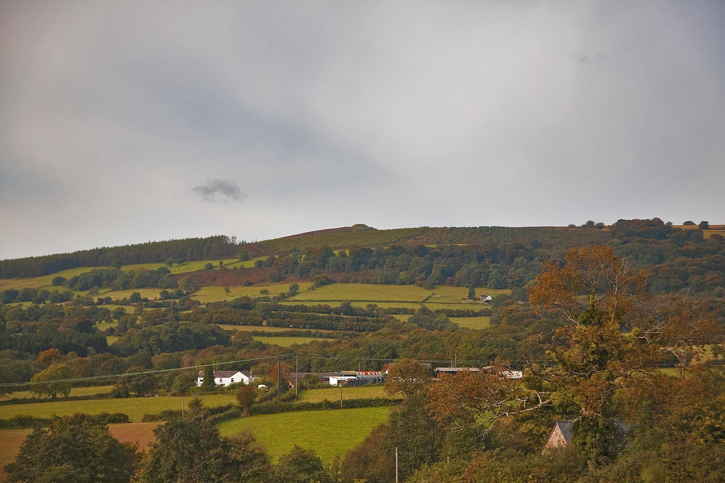
Mynydd Twmbarlwm (OS Grid ref: ST 24390 92660) (51.627654, -3.093715) rises to a height of 419 metres (1,375 feet) it is situated to the north of Newport in SE Wales above the town of Risca. Its outline is the first mountain ridge that visitors see as they enter Wales over the Severn Bridge – its western tip is dominated by the distinctive shape of the “Twmp” which is the Scheduled Ancient Monument revered by locals and shrouded in legend and mystery.
Mynydd Twmbarlwm and the adjoining common land area of Mynydd Maen and Mynydd Henllys – are situated within the Caerphilly and Torfaen County Borough Council areas. The area is a distinct, dramatic and iconic landform that can be viewed from most of the Local Authorities in the South Wales region as well as many counties across the border and the Bristol Channel.
Access by vehicle is quite discrete and fairly restricted, from Risca there is a single track country lane which runs to the base of the SAM and a car park which is an ideal base to start a walk to the ridgeway and summit (see description below how to get there). The northern slopes of the mountain fall into the Nant Carn valley, the location of the very popular Cwmcarn Forest Drive and Visitor Centre renowned for its forestry walks and mountain bike tracks – two or three car parks on the Forest Drive are good starting points for a trek to the top. (See the Walking section for more information).
The dramatic vistas from Twmbarlwm are a reason why this area is frequented by many locals and visitors. Those who trek to the top are rewarded with magnificent views over the Severn Estuary to the south and the Brecon Beacons to the north – on clear days the panorama includes seven counties.
MAPS
The Ordnance Survey map required is Landranger 171, OS Explorer 152 or Pathfinder 1300
Click here to see a video of the the route up to the Tump’s carpark from the Risca bypass (A4607) – it’s compiled from Google Street View images.
Find your way to Twmbarlwm and explore the area using Googlemaps below:
View Larger Map
DIRECTIONS TO THE “NEW CAR PARK” FROM THE M4
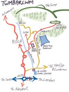
Click on the map to download a PDF which you can print out to help you find your way to Twmbarlwm
What3Words location (for car park) = [ironic.sweetened.people]
What3Words location (the Twmp) = [graphic.impresses.deadline]
Nearest post code is Maes Mawr Farm – the car park is another 400 yards past the farm NP11 6FY
The general meeting place for our Twmbarlwm events on the mountain is what we refer to as the “New Car Park” or “The Car Park on the Common below the Tump”. The car park is an ideal starting point as it is only half a mile to the summit (albeit very steep) – or half a mile up onto the ridgeway where the walking then becomes quite level for miles.
The car park is situated at the end of Mountain Road which is a single track country lane leading up from Risca Comprehensive School and Leisure Centre. There are quite a few passing places but you should take the road slowly and be prepared for oncoming traffic.
Take Junction 27 (Highcross) off the M4, take the B4591 towards Risca, follow road for 2 miles, just after the second roundabout you will see a sign for Risca Leisure Centre – turn right here onto Pontymason Lane – follow the road for about 1 mile.
You then come to a mini roundabout which marks the vehicle entrance into the school – go straight over the roundabout 100 yards after the mini roundabout turn right into Mountside and follow the lane.
150 yards up this lane you come to a T junction – this is Mountain Road – turn left.
Just follow this road – after about 1.5 miles you go over a cattle grid which we regard as the entrance to our mountain.
Carry on for another half mile and you will see a stone cairn welcoming you to Twmbarlwm – and behind it is the tarmac, circular car park.
You can go no further – get out and enjoy the scenery.
NOTE: There is no vehicle route from the Cwmcarn side of the mountain to the Risca side.
CROSSKEYS RUGBY CLUB
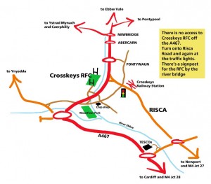 We hold meetings and events at Crosskeys Rugby Club, Pandy Park – here’s another quick map to help you find it.
Particularly note that there is no access to Pandy Park from the A467 (the Risca/Crosskeys Bypass)
If coming fro the north (Ebbw Vale, Newbridge etc.) – on the 467 you come to a roundabout with a large sculpture of a mountain biker on it, sign posted to Cwmcarn Forest Drive and Pontywaun – go straight on at that roundabout and after half a mile turn left into Crosskeys, then at the traffic lights turn right onto Gladstone Street. Shortly after the chip shop on the left is a river bridge where there is a signpost to the right for the Crosskeys RFC car park.
If coming from the south (Newport, Cardiff etc.) – use the A467 to bypass Risca – at the next large roundabout, take the 2nd exit onto the B4251 signposted for Wattsville (and Crosskeys RFC) after 150metres turn right – after 0.6 miles turn left into Crosskeys RFC.
You will also see a rather lovely mosaic on the wall at the turning into the entrance of the club.