Twmbarlwm – a Bibliography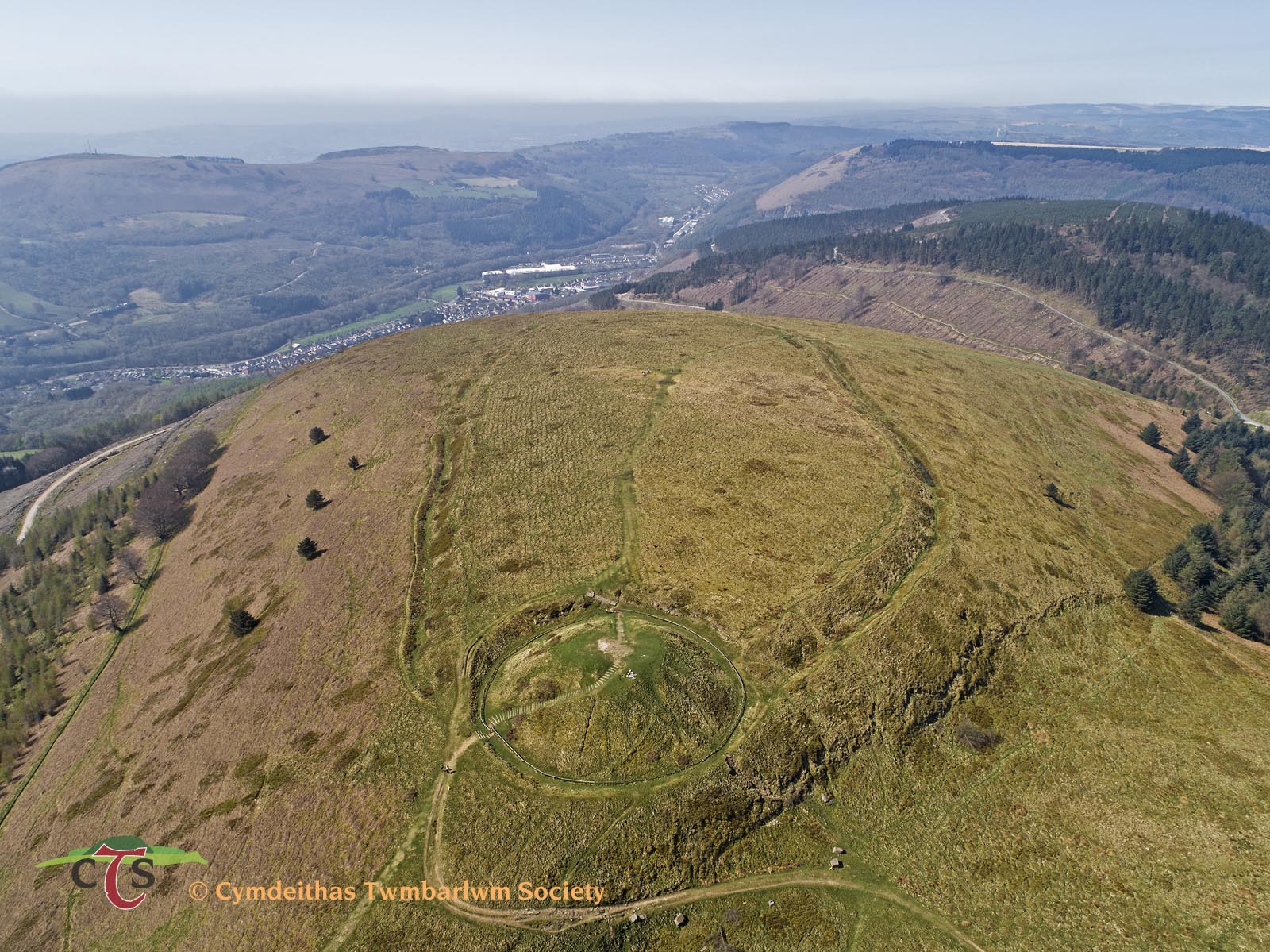
by Will Davies (Cadw Inspector of Ancient Monuments)
I promised the Society that I would attempt to produce a list of available published works for Twmbarlwm MM044 Motte and Bailey Castle to help all those who want to take their own research further – and hopefully this document will become a useful tool to help with the archaeological investigation of the scheduled monument of Twmbarlwm that we are about to embark upon in 2020.
I stress that this should be considered a live document and I would be grateful to add your suggestions or items that I have inevitably managed to miss.
I have listed anything with a specific reference to Twmbarlwm and have included a range of sources from antiquarians, to modern archaeology, hillforts, castles and folklore. Whilst I could have cast the net wider to provide some broader reading on specific topics i.e. timber castles, hillforts, the Silures etc. this would make it more difficult for you to filter out books or articles with direct references.
For the sake of brevity I have also largely avoided other nearby features on the slopes below or along the ridge of Mynydd Maen which is another task again, beyond the very specific monument that was seriously damaged by the wildfires in 2018.
The references below vary a lot, from brief appearances in lists, footnotes or on maps to short gazetteer entries and more detailed descriptions or discussions of varying length in books, articles and unpublished reports. All of these should be available at a decent library or online – and I include as many HTML links as I can to ease navigation to relevant sites.
Newport Libray’s reference section will have the journals such as Archaeologia Cambrensis and Archaeology in Wales whilst quite a few of the books should still be in print, or can be found in the usual second-hand shops.
The short summary is to help you to filter through this material i.e. who has done what and where, and is not an evaluation of the origin and nature of the monument or the broader archaeological context of the entire ridge. These will come when we produce the excavation report.
(Explore the Gallery Menu above for more Drone Survey Photos)
Overview.
Early references and antiquarians
 Whether you consider them to be Prehistoric, medieval or almost anything in between, the earthworks on Twmbarlwm are unknown to history until the post-medieval period when the hill began to appear in property deeds and the first cartographers and antiquarians first explored the historic county of Monmouthshire.
By the end of the medieval period Twmbarlwm lay within the Norman Lordship of Newport, initially carved from the lowland, coastal portion of the Welsh territory of Gwynllwg between the Usk and the Rhymney, the uplands of the Ebbw, Rhymney and Sirhowy to the north remaining in Welsh hands until they were annexed by the de Clare family in the 1260s and became part of Newport.
Until then Twmbarlwm would have stood somewhere on the boundary between Newport to the south, Welsh-held upland Gwynllwg to the north and the Lordship of Caerleon to the east, which fluctuated between Welsh and Norman control. In spite of its border location and prominence in the landscape Twmbarlwm does not seem to be mentioned in any medieval inquisitions or lordship accounts of land holdings and their boundaries although its presence in later deeds might suggest that further careful study of early sources might locate some indirect references. It is this backdrop of shifting territories and power that should be borne in mind when considering some of the more recent interpretations of the monument explored below.
The remoteness of Twmbarlwm and much of the rest of the Ebbw and Sirhowy Valleys from the main 18th and 19th century tourist routes dictated that whilst it is clearly visible for many miles around there are relatively few antiquarian references as few actually visited it. As such, many of the most likely sources of information omit it entirely, notably Sir Joseph Bradney who died in 1933 leaving his monumental History of Monmouthshire incomplete at its final volume covering the Lordship of Newport and the former Welsh Gwynllwg.
 Although some of the folkloric references to bees and wasps, the pool of avarice and even diggers into the mound being frightened by thunder relayed by Hando (1944), Roderick (1983, 1986), Palmer (1998), Barber (1983, 1987) etc may well have much earlier origins, Twmbarlwm’s first documentary appearance, albeit of the hill only, is to my knowledge by Henry VIII’s topographer and antiquarian John Leland. Leland visited the area between 1538-43, noting in passing during his account of the southern reaches of the Ebbw that ‘..there is a very Highe Hille caulled Tumbarlum’ (Itinerary Vol. III, 32), implying that he had only viewed it from a distance.
A few years later in 1587 Thomas Churchyard mentions Twmbarlwm in his poem ‘The Worthiness of Wales’ but also alludes to the earthworks on its summit. Having just described the hill fort on Lodge Hill above Caerleon he states:
‘Not farre from this, much like unto the same,
Tombarlown stands, a mountaine of some fame’,
A margin note adds ‘A wonderful high mountaine with the like manner of defence’.
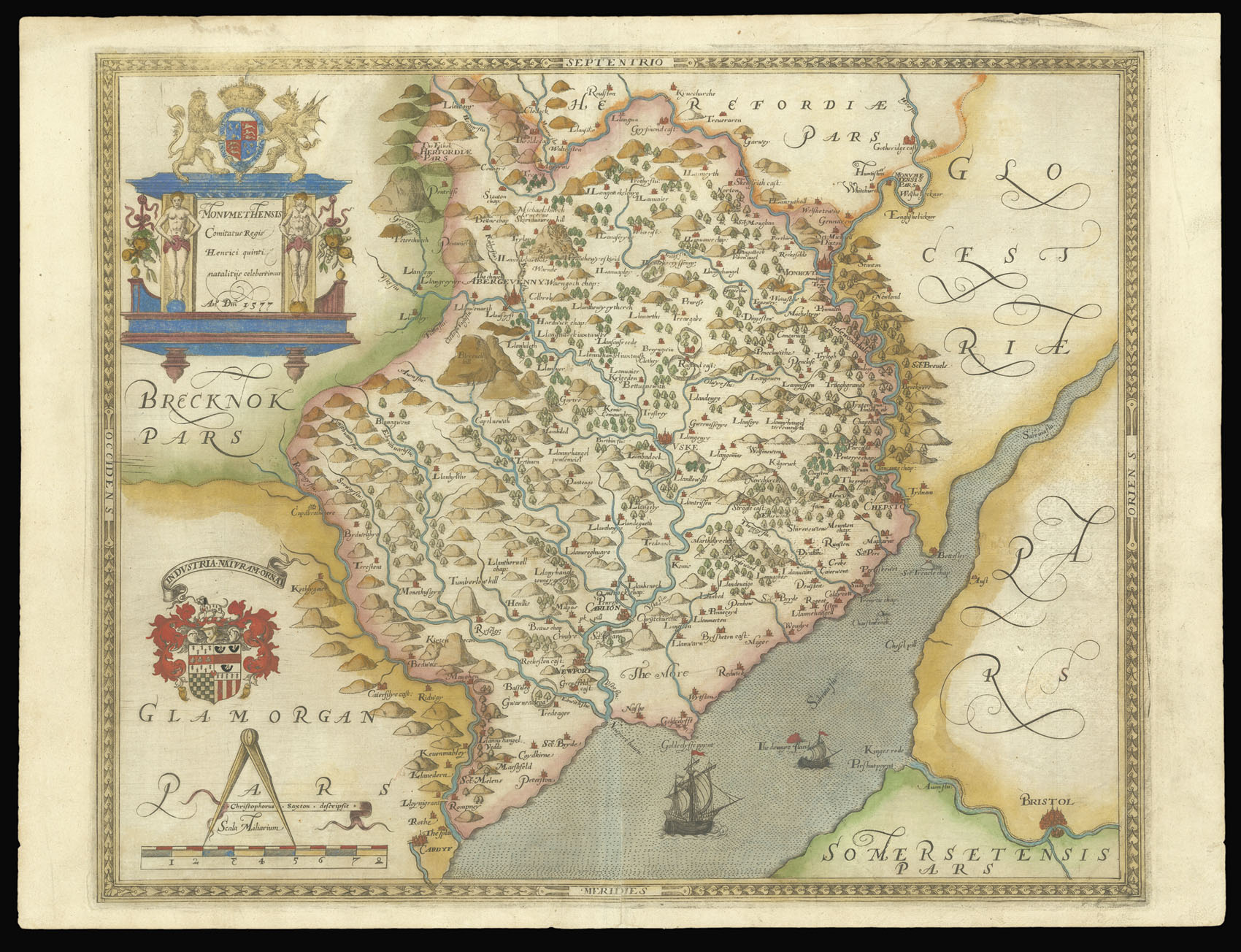
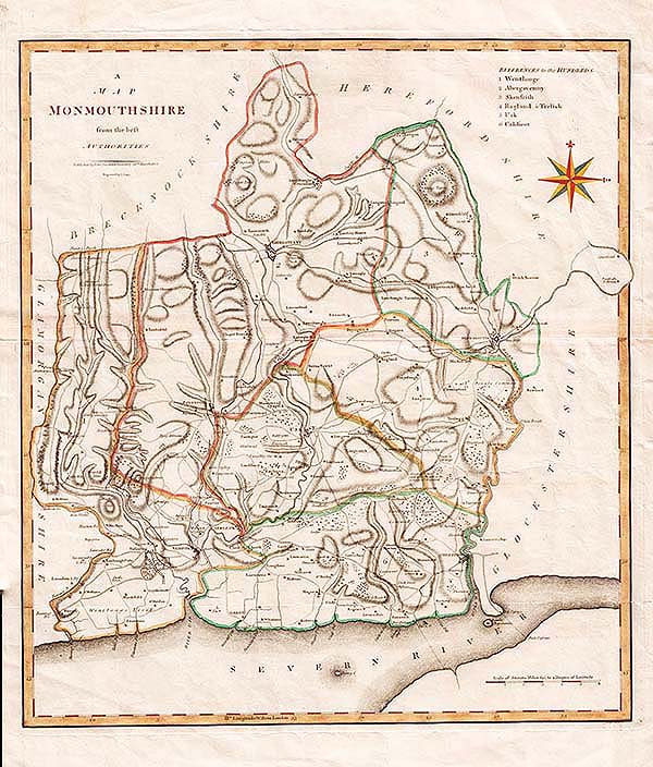
A decade earlier ‘Tumberlow Hill’ appears as a mole-hill like lump on William Saxton’s Map of 1577, followed by John Speed in around 1610. This corruption of presumably unfamiliar Welsh was followed numerous times and occasionally varied by subsequent cartographers, including ‘Pentwynbarhen Hill (Robert Morden 1695), ‘Tumberton Hill (Thomas Badeslade and William Henry Toms, 1742). Of these, John Cary (1787) appears to be the first to indicate the enclosure – or at least the higher summit at the end of the ridge rather than simply a schematic conical hill, and was closely followed on subsequent county maps. For those with a specific interest in this the early mapping of Monmouthshire is explored in detail with many examples by DPM Michael (1985).
The first published description of the monument itself is in Archdeacon Coxe’s Historical Tour in Monmouthshire. Few county antiquarians in Wales and the Marches provide so much useful information, Coxe’s detailed descriptions being greatly enhanced by the engravings of Colt-Hoare and in this case by the remarkably accurate measured surveys of T.E. Morrice. This shows the mound, the small cairn on the lip of its ditch, the pond and three of the breaches or gaps on the western and south-western arc of its defences. Coxe assumed the mound to be the burial place of a fallen Silurian chieftan (1801, 75) and like other early writers i.e. Bradney, identified many of the motte and baileys in the county as ‘British encampments’.
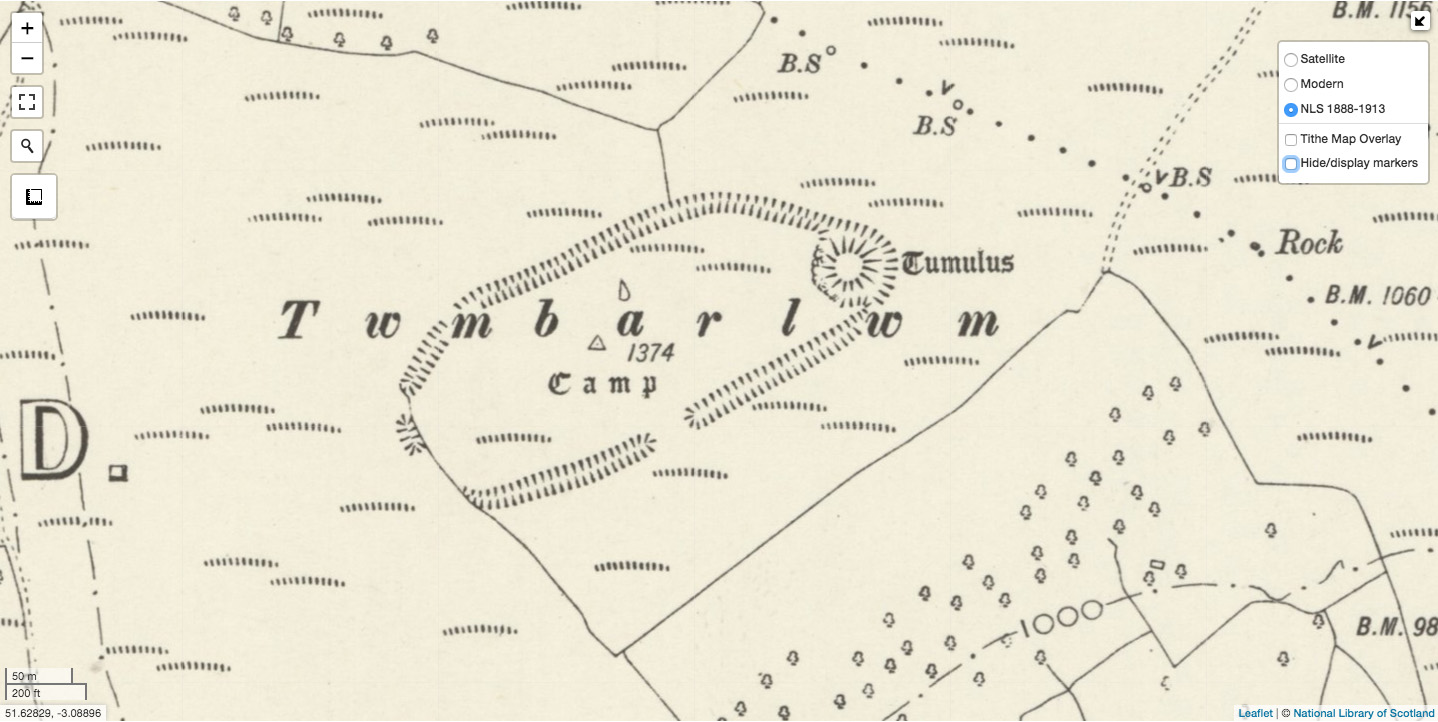 I know of no other 19th century descriptions of the monument but the Tithe map for Risca of 1843 depicts ‘Mynydd Twyn Barlwyn’ in plot 191, when it was owned by John Jones Esq. and occupied by one Mary George along with extensive tracts of pasture around the southern sides of the hill. Here it is drawn in more schematic detail with the enclosure as an unbroken raised area but with the motte still distinguished at its eastern end. It is notable that the Tithe lists the summit as enclosed pasture distinct from the common land along the ridge to the north-east; field are boundaries are drawn downslope from the enclosure, one apparently extending from the northern defences. The first edition Ordnance Survey drawn in the 1870s is similar to Morrice’s plan with the exception that the southern gap in the defences is depicted a little further to the east and that the boundaries shown on the Tithe are reproduced.
The 20th century to the present.
The first archaeological descriptions of the site appeared in the early 20th century when the first great gazetteers of castles and hill-forts were being compiled and by the middle of the century the great mound had become broadly accepted as a medieval motte rather than a barrow (e.g. Savory, 1950, Hogg & King 1963, Forde-Johnson 1976). The origin of the adjoining enclosure remains the subject of debate, most authorities favouring either an Iron Age hill-fort, a very large castle bailey, or a bailey re-using and earlier hill-fort. Beyond such basic identification more recent writers and researchers have explored in more detail a range of different scenarios for the likely date of establishment and function of both mound and enclosure, which are based upon a combination of the physical form and layout of the earthworks and their broader landscape and political context.
 The monumental Royal Commission inventory on early Glamorgan castles favours an early post Conquest date for the mound. It places Twmbarlwm into a group of undocumented mottes on the fringes of the uplands to the north of Cardiff with no clear manorial context, speculating that it may have formed part of a short lived chain of castles protecting the caput of Glamorgan Lordship at Cardiff prior to a regional Welsh resurgence in the 12th century (1991, 21, 59). Geoff Mein comments on a John Sorrell aerial photograph, noting the irregular mounds of up-cast from the enclosure ditch to form the unfinished rampart, suggesting a ‘hasty’ and unfinished refortification of an Iron Age site to form a castle bailey (1997). Both Forde-Johnson (1976) and Hannah Wiggins in a Cadw-funded assessment of prehistoric enclosures in Monmouthshire (2006) both interpret the enclosure as an unfinished hill-fort, Wiggins noting its apparently featureless interior. Neil Phillips (2006) undertook the first modern topographic survey as part of his PhD research on early castles in the region, observing that the mound itself had primarily been created through the excavation of the great rock-cut ditch rather than built up, and also accepted an Iron Age date for the enclosure. He concluded that the motte formed the base of an early ‘watch tower’, citing the lack of obvious contemporary settlement, its highly visible position and drawing comparison with a range of other hilltop mottes in the area. He does not attempt to place the site into its political or lordship context but does acknowledge an argument for a later date by Knight and others (see below).
Stuart Prior’s flawed and error-strewn Monmouthshire case study in his book on warfare and Norman castles expands upon the watch-tower hypothesis (2006). This cites Roman military theory and again draws superficial parallels with a range of other sites in the region, stating with some confidence that it was built ‘between 1135 to 1165’, ostensibly to protect lowland Newport lordship from Welsh incursions, but without any supporting evidence. An alternative scenario but again without direct supporting evidence is that Twmbarlwm was associated with the annexation of the uplands of Gwynllwg into their Lordship of Newport in the 1260s by the Clare family (Whittle, 1992).
The Clare theory was followed by Howell (2016), and Knight (2019), who interpret the enclosure as the remains of an unfinished castle bailey, again drawing attention to the irregular up-cast mounds of spoil for its incomplete rampart and the sharp profile of the ditches as evidence. Knight also notes similarities in location at the edge of its lordship to Gilbert II de Clare’s huge and equally lofty masonry castle at Morlais, albeit on an entirely different scale to Twmbarlwm. John Wiles also provides a description with measurements, noting the apparently remote location for a medieval castle, raising the possibility that it functioned as a hunting seat within Newport lordship (2008).
Finally, I include a quote from W.H. Greene, a 19th century journalist, antiquarian and prolific sketch artist who recorded many now vanished historical features in Newport and Monmouthshire. Whilst not directly referring to Twmbarlwm it is still very relevant to our project. Writing about the northern, Tranch end of Mynydd Maen he stated that ‘…if the present drought continues, it is possible that the mountain top may again take fire, and flare for weeks, as it did in the summer of 1868’. Damaging as it may have been the hill recovered from this episode of burning and probably many other unrecorded ones. Moreover, the fires have presented us with an opportunity to better understand Twmbarlwm; firstly in exposing and enabling us to document previously unknown hut-like features within the enclosure. Secondly the forthcoming excavations will help to clarify the form and construction of the defences and these structures, potentially providing artefactual and dating evidence and with luck allowing us to move beyond some of the informed speculation above.
Will Davies, Cadw, December 2019
The Bibliography:
Barber, C. 1983 – Mysterious Wales. Paladin, 65-6
Barber, C. 1987 – More Mysterious Wales. Paladin. Pp39, 49
Churchyard, T. 1587 – The Worthiness of Wales. Thomas Evans edition, London, p49.
Coxe, W. 1801 – An Historical Tour in Monmouthshire. London
Crouch, D. 2008 – The Transformation of Medieval Gwent. In Griffiths, R.A, Hopkins, T. & Howell, R. (Eds.) ‘Gwent County History Volume II. The Age of the Marcher Lords c1070-1536, pp 1-43. (photo only
Dowman, Rev. MSS Newport Reference Library
Forde-Johnson, J. 1976 – Hillforts of the Iron Age in England and Wales. Liverpool. pp105, 122
Greene, W.H. 1868 – A Trot to Crumlin. In Walkinshaw, D. ‘The Local Register or Chronology of Pontypool from the earliest period. The Free Press of Monmouthshire (4th edition).
Hamilton, M.A. 2004 – The Bronze Age. In Aldhouse-Green, M. & Howell, R. (Eds.) , ‘The Gwent County History Volume I. Gwent in Prehistory and Early History’, pp84-110 ,Cardiff.
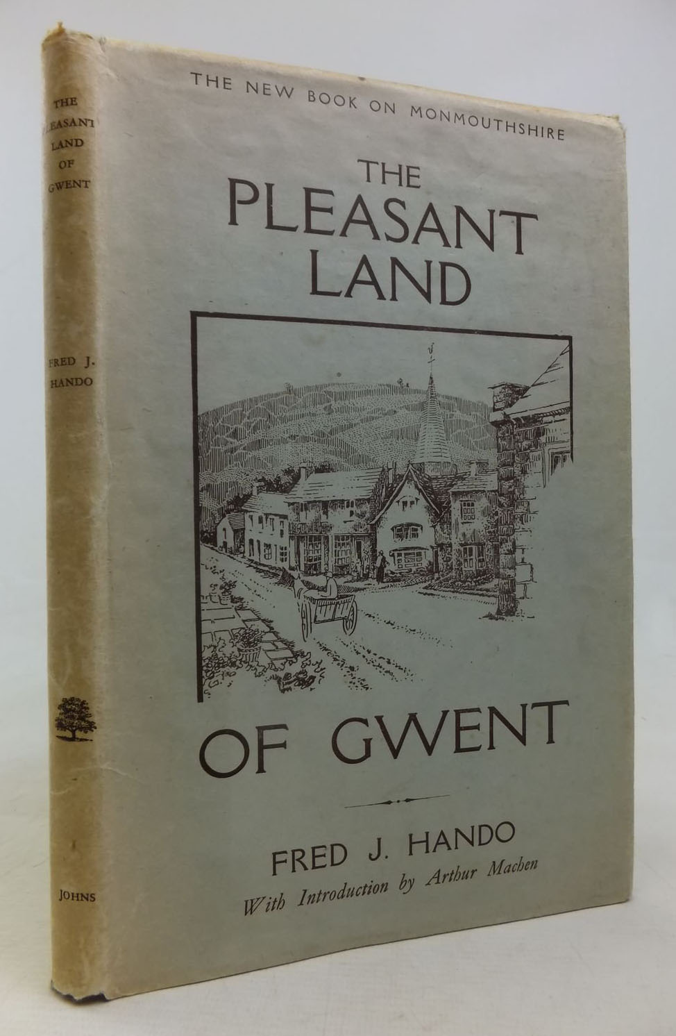
Hando, F.J. 1944 – The Pleasant Land of Gwent. Newport., pp28-9
Hogg, A.H.A. 1960 –
Hogg, A.H.A. and King, D.J.C. 1963 – c. Archaeologia Cambrensis Vol. 112, pp77-124
Howell, R. 2009 – Searching for the Silures: The Iron Age in South-East Wales. The History Press.
Howell, R. & Pollard, J. 2004 – The Iron Age. In Aldhouse-Green, M. and Howell, R. ‘The Gwent County History Volume I. Gwent in Prehistory and Early History’, pp140-159. Map only.
Kenyon, J. 2010 – The Medieval Castles of Wales. University of Wales Press
King, D.J.C. 1983 – Castellarum Anglicanum. New York, p287
Knight, J. 2019 – An Accidental Excursion into Monmouthshire. Castle Studies Group Journal no. 33, 2019-20. Pp 213-4
Leland, J. 1538-43 – The Itinerary of John Leland the Antiquary in Nine Volumes, Vol. III. Fletcher and Pote Edition 1711, p32. Link below:
https://archive.org/stream/itineraryjohnle08heargoog#page/n6/mode/2up/search/tumbarlum
Mein, A.G. 1997 – Twn-Barlwm, Caerleon. Archaeology in Wales 37, p 105
Michael, D.P.M. 1985 – The Mapping of Monmouthshire. Bristol
Newman, J. 2000 – The Buildings of Wales. Gwent / Monmouthshire. Penguin. P515
Olding, F. 2016 – Archaeoleg Ucheldir Gwent / The Archaeology of Upland Gwent. RCAHMW.
OS Record Card
Palmer, R. 1998 – The Folklore of (Old) Monmouthshire. Logaston.
Pickford, J.A.F. 1946 – Between Mountain and Marsh in the Hundred of Wentllwg, Monmouthshire, R.H. Johns (p50)
Phillips, N. 2006 – Earthwork Castles of Gwent and Ergyng AD 1050-1250. British Archaeological Reports. pp341-2
Pollard, J., Howell, R. & Chadwick, A. 2006 – Lodge Hill Camp, Caerleon and the Hillforts of Gwent. British Archaeological Reports (British Series) no. 407
Prior, S. 2006 – A Few Well-Positioned Castles: The Norman Art of War. Tempus
Roderick, A. 1983 – Folklore of Gwent. Village, Cwmbran. pp83-6
Roderick, A. 1986 – Unknown Gwent. Village, Cwmbran. pp63, 65
RCAHMW 1991 – An Inventory of the Ancient Monuments in Glamorgan Vol. 3 Part 1a: The Early Castles. HMSO.pp 21, 59
Savory H.N. 1950 – List of Hill-Forts and Other Earthworks in Wales: II Monmouthshire. The Bulletin of the Board of Celtic Studies : XIII pt.IV : 231-238 (p234)
Whittle, E. 1992 – A Guide to Ancient and Historic Wales: Glamorgan and Gwent. HMSO
Wiggins, H. 2006 – Prehistoric Defended Enclosures in Gwent. A report for Cadw. Glamorgan Gwent Archaeological Trust Unpublished report. GGAT no 2006/021
Wiles, J. 2008 – Twmbarlwm Castle Mound. Coflein website (See link below).
Online
Coflein – This is the online database entry for the National Monuments Record of Wales (NMRW). The link below is to the Twmbarlwm entry which includes a number of good photographs of the site, a list of all NMW archive material, including descriptions of the earthworks by John Wiles of the RCAHMW in 2008 and more recently by Paul Davis in 2019. Hard copies held at the NMR in Aberystwyth.
https://coflein.gov.uk/en/site/307848/details/twmbarlwm-hillfort-and-castle
Archwilio (GGAT area) – The online portal for the four regional Welsh Historic Environment Records maintained by the Welsh Archaeological Trusts, in this case Glamorgan Gwent. Can be searched by map or text box – note that the different elements of the site i.e. motte, trig point, defended enclosure have their own records and spellings vary. Contains further bibliographic references, hard copies held at the actual HER by GGAT.
https://www.archwilio.org.uk/arch/
CofCymru – Cadw’s online database of all designated historic assets (scheduled monuments, listed buildings etc). A short summary description only but good mapping showing the extent of the scheduled area.
https://cadw.gov.wales/advice-support/cof-cymru/search-cadw-records
Online Hillfort Atlas. AHRC funded collaborative project. Doesn’t add anything not contained in the above on Twmbarlwm and far from a comprehensive database but a useful tool of reference with handy links to aerial views and bibliographic material for sites across the UK.
The specific entry for Twmbarlwm – http://hillforts.arch.ox.ac.uk/records/WA1545.html
Gatehouse. The late Philip Davis’ mindboggling database of all definite, possible and rejected castles and fortifications in England and Wales. There are county gazetteers with bibliographies for each site and links to aerial views. The below is the link to Twmbarlwm but as with the other sites above, you can browse through this for hours.
http://www.gatehouse-gazetteer.info/Welshsites/614.html
This archaeological investigation is funded by:
Ariennir yr ymchwiliad archeolegol hwn gan: