Twmbarlwm Awe Walk #01
TWMBARLWM “AWE WALKS”
A recent study by scientists from Trinity College, Dublin and the University of California have shown that short “awe-walks” (blame the Americans for that term) can greatly increase positive emotions and help maintain a healthy mind. An “awe-walk” is not about the length or difficulty of the walk but one where you make a conscious effort to look for things that will truly amaze you.
Personally speaking I didn’t need any scientist to tell me that, as it only proves what I’ve always believed -– and it suits me down to the ground, because having Twmbarlwm mountain on our doorstep, my fitness and continued mental well-being is assured. So I thought I would share with you a few “awe-walks” that I often follow.
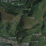
The distance and steep climb from the valley floor in Risca or Cwmcarn to the top of Twmbarlwm can be a little challenging. Thankfully the mountain is easily accessible by car, and using the car park on the common below the Twmp as a starting point there’s any number of short walks possible with viewing points offering the necessary “wow-factor”.
Most of the “awe-walks” I take are less than two miles and yet often take me a couple of hours because of my frequent stops to sit and take in the views. Apart from a few places that are a bit steep, if my bad knee and general health can handle these walks then anybody should be able to – you won’t get lost up here either, the car park is easily visible from the Twmp.
“AWE-WALK” #01
From the car park the natural instinct is look up at the mountain and head straight for it – up the small flight of steps and follow the path up along the fence-line. It’s only half a mile to the top but it is very steep for the first half of the walk.
Speaking for myself I get short of breath quite quickly and I have a bad knee so nowadays I usually take the route described below – it is a more gradual incline than going straight up to the Twmp from the car park and there’s plenty of places to rest up and to take in the AWEsome views. The entire walk is just under two miles and you take in all that this beautiful mountainside has to offer – and if I can do it, so can you.
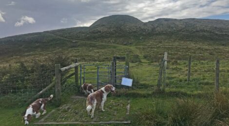
01 – Go through the mountain gate to head up the rough track that we simply refer to as the ORPA (Other Route for Public Access). This tracks heads North. The big metal gate should always be closed as it is there to prevent the livestock getting out onto the lower common, so please make sure it is closed. Being the entry to a public highway means it must not be permanently locked.
. This tracks heads North. The big metal gate should always be closed as it is there to prevent the livestock getting out onto the lower common, so please make sure it is closed. Being the entry to a public highway means it must not be permanently locked.")
|

|
02 – The ORPA is very rocky but at least the gradient is not as steep as the direct route to the top. After just 200m the view to your right is starting to open out – have a pause to take it all in – immediately down below you there’s a large beech tree on the fenceline – if you’re there in springtime there’s every chance of spotting a Cuckoo there. Let your gaze go a bit beyond that tree and you’ll notice a large stony tump – that’s a bronze-age burial mound one of several along that ridge. Beyond that is the City of Newport, the Severn Estuary and the coast of the west country from Clevedon to Weston Super Mare. You can already pick out some notable landmarks like the Severn Bridge, Newport’s Transporter Bridge and Uskmouth Power Station all of which will be clearer as you get up higher.
03 – Onwards up the ORPA – until you come to what I call the crossroads – climb up onto the embankment and give your dog a few biscuits (at least that’s what I always do at this point). The next four photos show what you can see in each direction – straight ahead is the track we’re going to be taking up onto the ridgeway, but first of all look left and you get your first proper view of the Twmp (the hill fort) in all its glory – always a WOW! moment for first time visitors here.
The actual route of the ORPA is signposted and goes off to the right (and will feature in a later walking route) – all the other tracks you see going away from this point are not public highways and should not be used by motorised vehicles.*
 - all the other tracks you see going away from this point are not public highways and should not be used by motorised vehicles.*straight ahead is the track we’re going to be taking up onto the ridgeway, but first of all look left and you get your first proper view of the Twmp (the hill fort) in all its glory - always a WOW! moment for first time visitors here.Look right and you’re looking down onto Cwmbran across to Llanfrechfa and the new Grange Hospital on the horizon - to the right of that is Caerleon (the famous Roman settlement of Isca) - and further right again you now have the full expanse of the City of Newport below you.The wooded ridge in the distance is Wentwood (out towards Caldicot and Chepstow) and on a clear day if you look carefully you can see the top of the towers of the first Severn Bridge peaking over the top the trees (you\'ll get a better view of it later on).")
|
Look right and you’re looking down onto Cwmbran across to Llanfrechfa and the new Grange Hospital on the horizon – to the right of that is Caerleon (you all know about Caerleon being the major Roman town of Isca) – and further right again you now have the full expanse of the City of Newport below you.
The wooded ridge in the distance is Wentwood (out towards Caldicot and Chepstow) and on a clear day if you look carefully you can see the top of the towers of the first Severn Bridge peaking over the top the trees.
Okay – we’ve only done 500m so let’s crack on – there’s not much more uphill. Straight on up the track directly in front of you. After 250m you reach the ridgeway – again the next four photos show the views in each direction.
07 – You may need to wander into the ferns for a few metres to see the view north but in that direction you’re looking straight up towards Abergavenny and Brecon. The hillside directly in front of you that has been cleared of all its forestry is the Gwyddon and in the valley below id the Cwmcarn Forest Drive – you’ll get a better view of that as we go towards the Twmp.
08 – To the right you are looking across the extent of the ridgeway towards Pontypool – if you followed the ridgeway you would eventually drop down into Upper Cwmbran or Pontypool.

|

|

|

|
09 – Look to the left and you’re looking straight at our main goal, Twmbarlwm, and you get a better idea of the size and extent of the scheduled monument.
All the scarring of the landscape you see around you at this point is caused by illegal off-road motorcycles and 4x4s – but let’s ignore that for now and enjoy the 360° views.
The route towards the Twmp is now relatively flat and the views north and south open up to reveal different aspects as you go along.
10 – A couple of hundred metres before the Twmp, on the right is a new pond created by the commoners to provide water for their livestock and as part of their management responsibilities for this landscape

|
 - currently they are not on the path as repair and archaeological work is being undertaken. Please do not to attempt to go straight up the steep embankment to the top but follow the obvious path to the left - make a point of looking down at the rocks forming the path many contain fern-like fossils in them.")
|
And so on to the kissing gate that marks the entrance to the Scheduled Monument – you surely have to spend a while here to take it in. Mountain bikers should not ride across the Twmp but should dismount and walk across – we need to minimise the erosive effect visitors have on this wonderful, historic monument.
At the base of the slope up to the Twmp is a set of rocks originally put there to stop vehicular access (yes, people used to try to drive their cars to the top) – currently they are not on the path as repair and archaeological work is being undertaken. Please do not to attempt to go straight up the steep embankment to the top but follow the obvious path to the left – make a point of looking down at the rocks forming the path many contain fern-like fossils in them.
11 – And so to the steps up onto the Twmp – these steps were installed by the local council in the mid 1980s – at the top you will get the full 360° panoramic view that has been unfolding on your trek so far. Theoretically you can see seven counties from this 1,375ft vantage point and too many landmarks in far-off places to mention – you’ll see everyone here pointing off into the distance and asking “…is that the Millennium Stadium?”; “…which one is Pen-y-fan?”; “…is that Weston-Super-Mare?”; “…how far over is Ilfracombe?”; “…ooo look, that’s Tesco’s there!”
 - but it’s also worth walking around the outside ditch of the bailey part of this Mound and Bailey Castle. You’ll get some lovely views down into the Cwmcarn valley, up through the Ebbw Valley and up to Cwmfelin and Pontllanfraith in the Sirhowy Valley. Of course you have to get to the Trig point at the centre of the Bailey for the photo that says you got to the highest point in south Wales.")
|
Well worth spending half hour here (if the wind is not cutting you in half) – but it’s also worth walking around the outside ditch of the bailey part of this Mound and Bailey Castle. You’ll get some lovely views down into the Cwmcarn valley, up through the Ebbw Valley and up to Cwmfelin and Pontllanfraith in the Sirhowy Valley. Of course you have to get to the Trig point at the centre of the Bailey for the photo that says you got to the highest point in south Wales.
Back at the bottom of the steps either go straight down the grassy path aiming directly at the car park – but be warned it is very steep and can be slippery in the wet – or back around to the big rocks you passed on the way up and turn right there down a more gradual slope towards the car park. Both these paths eventually meet at a conveniently positioned bench overlooking the car park and lower common.

|

|

|
.")
|
Follow the fence line back down to the car park – again this is very steep and liable to be slippery. If you prefer you could go through the kissing gate alongside the bench and head back to the crossroads mentioned at point three, and back down the ORPA to the car par – this route home adds just over half a mile to the trip.
Including the walk around the bailey part of the Scheduled Monument this walk is only 1.9 miles and should only take 45 minutes if you don’t stop – but the idea of these walks is to stop and contemplate the awesome views and recharge those mental batteries – so it often takes me over two hours.
* All the land you are walking on up here is Common Land subject to Common Law – there are no Public Highways along the ridgeway of Mynydd Henllys and Mynydd Maen even though they may look like it. No motorised vehicles (motorbikes or cars) should be on these tracks without the permission of the landowners. The police mount regular surveillance exercises in this area and offenders caught using vehicles are liable to have their vehicles seized and possibly destroyed.