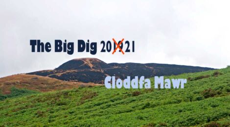
Twmbarlwm Dig 2021 – Summary
The Society is just about to re-start the archaeological investigation that we have been engaged in for the past few years with CPAT (The Clwyd Powys Archaeological Trust), under the guidance and support of Cadw.

We will be starting to dig a new series of trenches on Monday 8th August – but before I start this year’s Blog of the project, perhaps you would like to see CPAT’s “Non Technical Summary” of the report of what we achieved with last year’s dig.
You can download it in PDF format here
Twmbarlwm
Results of Archaeological investigations 2021
Non Technical Summary
Twmbarlwm is a scheduled monument (MM044) occupying a dominant position at the southern end of the Mynydd Maen ridge near Risca, Caerphilly. The monument includes a bank and ditch enclosure about 4ha in extent with a very large mound at the east end. The enclosure is conventionally understood to be an Iron Age hillfort, with the mound interpreted as a medieval motte, but as there has been no previous archaeological investigation of the site, the function and date of these massive earthworks is unproven. Internal features include a possible burial mound, a pond and potential hut-circles.
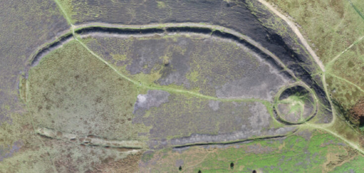
Aerial view of Twmbarlwm taken during a Drone Survey shortly after being devastated by wildfires in 2018
In 2021 archaeological investigations were carried out, under the overall direction of the Clwyd-Powys Archaeological Trust, designed to test whether the monument had been harmed by the effect of a large fire in 2018. Cymdeithas Twmbarlwm Society with permission of Llanarth Estates and in association with Cadw, agreed a programme of work to inform the restoration and revegetation of the site, and to improve its understanding and interpretation. Volunteers from the society helped with excavation and survey so that a detailed plan of the monument could be completed. The work included topographic and geophysical surveys as well as a drone photographic survey, which showed that the bank and ditch was not continuous and was possibly incomplete.
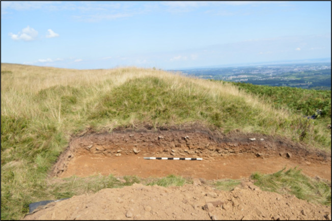
As part of the investigation three trenches were excavated. Trench One, excavated at the western end of the enclosure, showed an entrance way about 18m wide through the rampart. Soil samples were taken here to see if the entrance way could be dated, but, unfortunately, the process was inconclusive.
On the north-eastern side the enclosure ditch was the most significant part of the monument, with a deep ditch and the suggestion of a possible roundhouse which had been exposed to wildfires in 2018. Trench Two investigated this roundhouse but it appeared to be no more than stone rubble thrown up from excavation of the ditch. A third trench was also excavated across the ditch at this point. This showed that before it became infilled it was originally rock-cut, having a width of approximately 7m and depth of about 4m from the base of the bank.
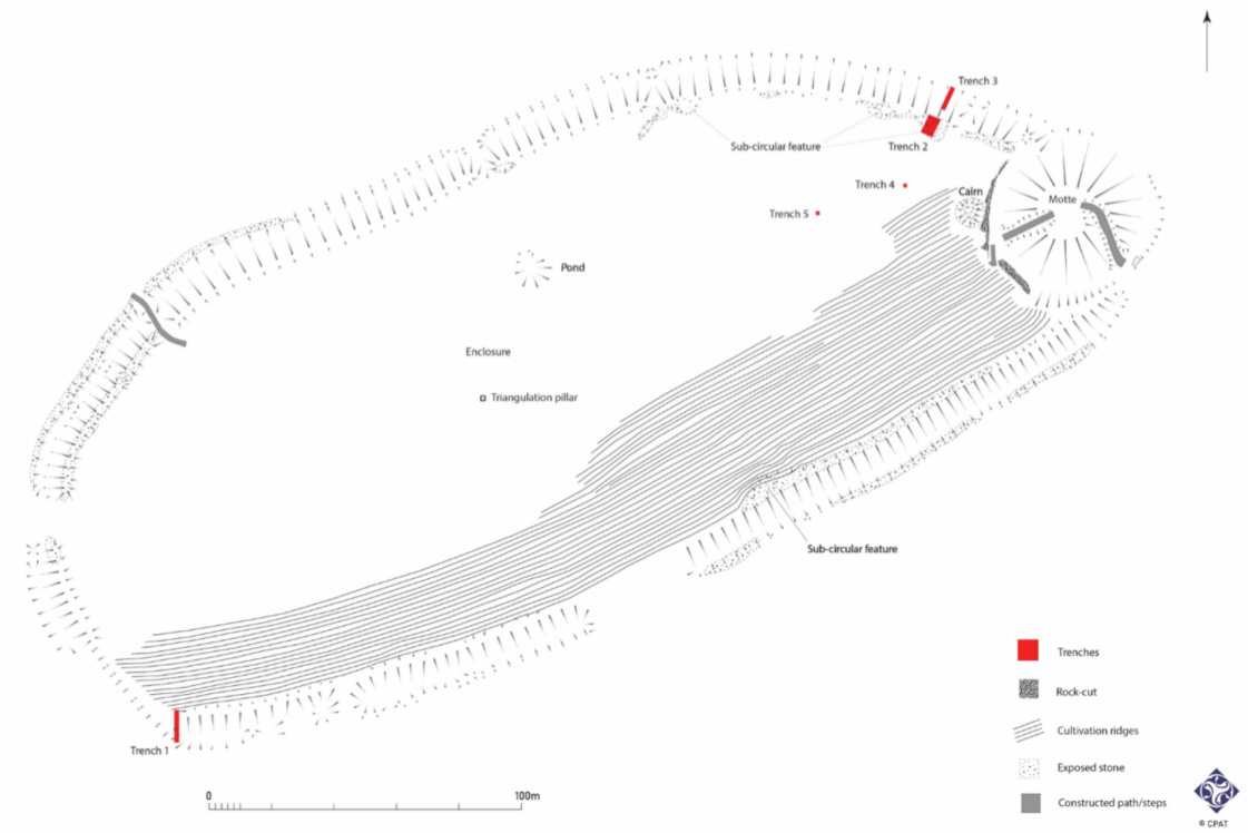
Accurate hachured diagram of Twmbarlwm produced by CPAT as a record for the current and future investigations. Also illustrating the positioning of the trenches dug in 2021
Trench 1 at at west end showing excavated profile through rampart. The core was constructed by a low earth bank with stones, presumably thrown up by digging the ditch. A second layer (the upper dark band in the photo) was found lying over the top of the bank and which spread downhill into the ditch so probably formed at a later period than the original bank.
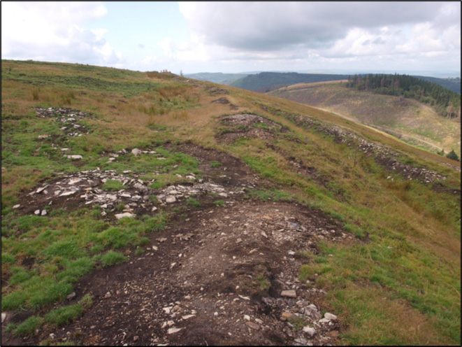
Circular stone “hut” adjacent to bank and ditch on north-eastern side of the enclosure. This is one of several structures revealed by the fires and which looked as though they were remains of stone-built roundhouses. Excavation of one, however, appeared to show a random spread of rubble rather any definite structure.
In excavating Trenches two and three, charcoal samples were found in two separate locations, one was found on bedrock in the ditch in trench three and contained remnants of Hazel stemwood and other short-lived species. This was radiocarbon dated between 175 and 26 BC which is late Iron Age. The other, found on sub soil in trench two on the edge of the rampart, contained evidence of Hazel and Oak and was dated to between 3105 and 2916 BC which is the Neolithic period.
The charcoal from the iron age was possibly the remains of fires used to break up the bedrock when excavating the ditch, this seems to confirm its use as a hillfort. The charcoal from the Neolithic period has raised the possibility of an earlier use of Twmbarlwm as a ‘causewayed enclosure’.
These monuments are rare and are characterised by intermittent ditch circuits hence the causewayed entrances in between. They have a general date range of 4000-3300BC and evidence from examples excavated in Dorset and Wiltshire provided evidence for feasting, with large quantities of animal bone in the ditches. Human bones have also been found, so their function is open to interpretation, with some archaeologists believing they were meeting places for markets and major festivals or ceremonies.
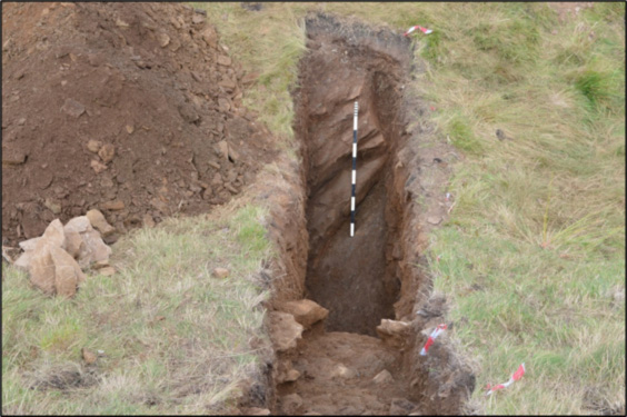
The rock-cut ditch at Trench 3
Samples were taken from an area of wet ground near the enclosure, to see whether pollen survived that could provide evidence of the changing environment since prehistoric times. The lower part of the sequence recorded a predominantly wooded local landscape, of hazel, birch, alder, oak and lime, holly, with only limited open grassy areas. Some oat pollen suggested agriculture in the general area.
The excavations have shown that the hillfort can be linked to the Iron Age, that the enclosure was never completed and that the possible roundhouse was simply a pile of stones possibly arising form the excavation of the ditch. It has also raised the intriguing possibility that Twmbarlwm may be an example of a ‘causewayed enclosure’ Subject to funding being available it would be useful to carry out further excavations to see if more evidence can be found to help date the enclosure, investigate the burial cairn and another possible roundhouse and date the motte by taking core samples.
Acknowledgements
The assessment involved a number of specialists, including Dr F Grant, who studied the palaeoecology of the site and C Matthews of Archaeological Survey West who carried out a geophysical survey of the monument. A UAV (drone) survey had already been carried out by Skywest Surveys in 2018, prior to the commissioning of the work by Cymdeithas Twmbarlwm Society, in association with Cadw who grant-aided the project.
The project could not have been undertaken without the support of the landowner, the Llanarth Estate, financial and practical assistance from Cadw and the help of volunteers from the Cymdeithas Twmbarlwm Society.
As the 2022 Dig progresses we will be publishing a daily blog – please make sure you follow us – and look out for announcements on FaceBook.
And remember if you think you could help in any way or if you want to get involved please email us at twmbarlwmsociety@gmail.com
The full technical report (draft copy) can be downloaded here